Site photo camera for builders

Every site photo, stamped and ready to report.

Lotstamp burns the time, GPS, address and project into every shot, pins it on the map and turns a day on site into a clean PDF or Excel report.

Get it onGoogle Play Coming soonApp Store
100×zoom on supported phones
PDF + XLSXreports in one tap
DXF · KMLoverlays on the map
Top features

Built for the way site records actually get made.

Take the photo, and the evidence is already on it. Lotstamp handles the location, the order and the paperwork so your report is finished before you leave site.

Camera

A camera that stamps the facts as you shoot

Open the app and shoot. Each photo carries proof of when, where and for which job it was taken, burned into the image so it can't drift away from the file.

  1. 1
    Project on screenCompany, project and level sit on the viewfinder so every shot is filed to the right job.
  2. 2
    Live GPS accuracySee signal strength before you shoot. Fix a pin or refine the address afterwards if needed.
  3. 3
    Full stamp, burned inDate, time, coordinates, altitude, compass heading, street address and optional weather.
  4. 4
    Zoom to 100×Lens zoom to the hardware limit, then digital zoom on phones with a long telephoto.
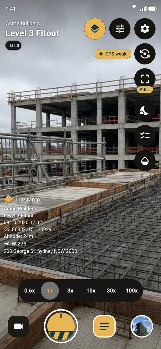
Lotstamp camera screen showing the stamp overlay and zoom controls
1 2 3 4
Map

See where every photo was taken, and which way it faced

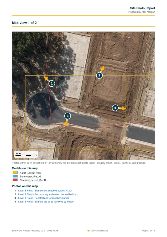
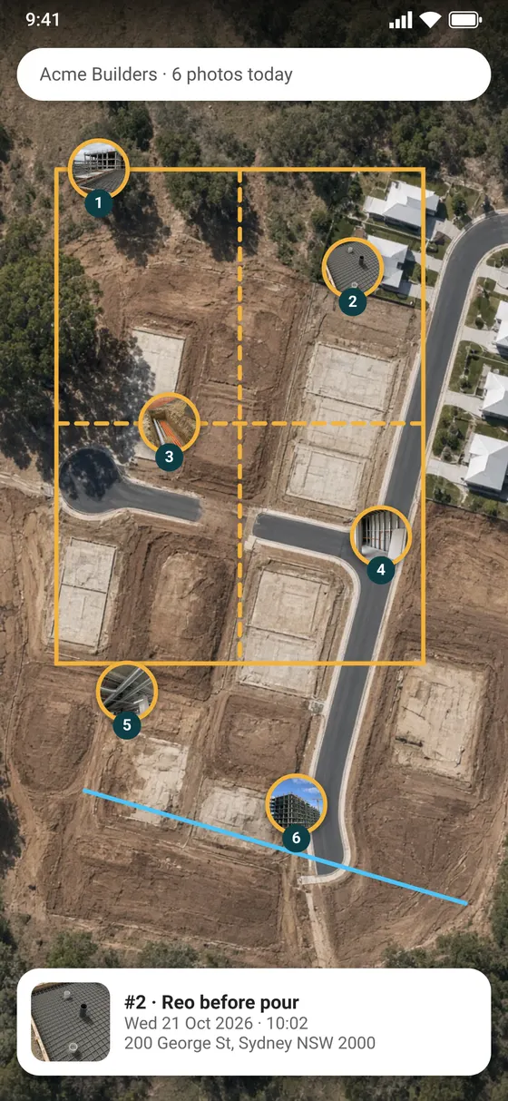
Photos land on a satellite map as numbered pins with a direction cone. Drop your site drawings over the top and the photos line up with the design.

  1. 1
    Numbered direction pinsEach pin shows the photo number and the heading the camera was pointed.
  2. 2
    CAD over satelliteImport DXF, KML/KMZ or GeoJSON. MGA/GDA2020, UTM and local grids supported.
  3. 3
    Tap to openTap a pin to see the photo, its note, time and address.
Map screen with numbered photo pins and CAD boundary overlay
1 2 3
Reports

From camera roll to client-ready report in one tap

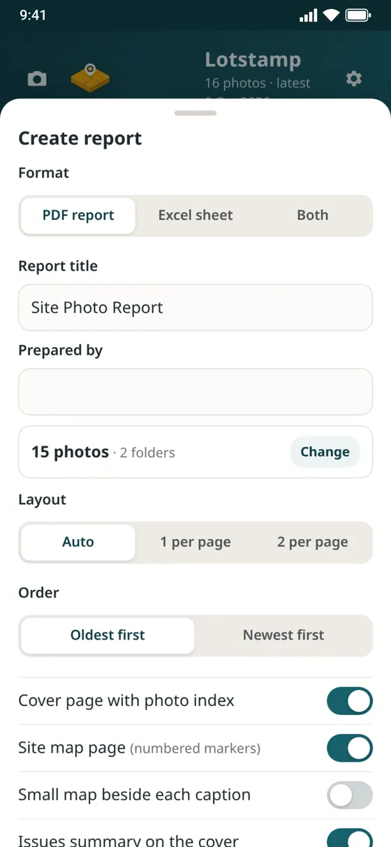
Pick the photos, choose a layout and send. Lotstamp writes compact PDFs that open fast on any device, plus an Excel sheet for your registers.

  1. 1
    PDF, Excel or bothA photo report and a spreadsheet of photos, defects and a summary.
  2. 2
    Your layoutAuto, one or two photos per page, oldest or newest first.
  3. 3
    Cover, map and issuesAdd a photo index, a site map with numbered markers and an issues summary.
Create report screen with format, layout and page options
1 2 3
Pro · Cloud sync

Backed up to your own Google Drive

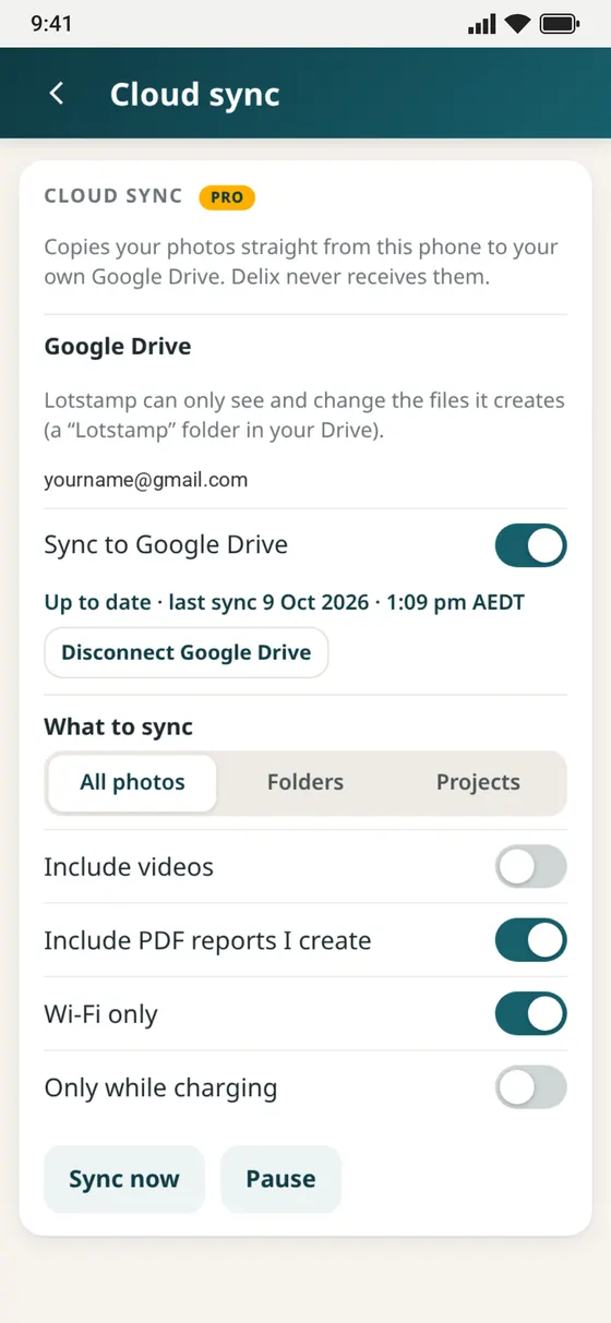
Photos copy straight from your phone to a Lotstamp folder in your Drive. Delix never receives them, and the app can only see the files it creates.

  1. 1
    Private by designYour photos go to your Drive and nowhere else.
  2. 2
    Choose what syncsAll photos, chosen folders or projects. Include videos and the PDF reports you create.
  3. 3
    Save your data planSync on Wi-Fi only, or only while the phone is charging.
Cloud sync settings for Google Drive
1 2 3
What your client receives

Reports that read like you spent the evening on them.

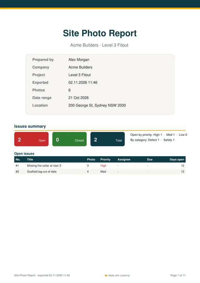
A cover with project details and open issues, map pages with numbered pins, marked-up drawings and every photo with its full stamp and your comments.

Report cover page with project details and issues summary
Cover · issues summary
Report map page with numbered photo markers
Site map · numbered pins
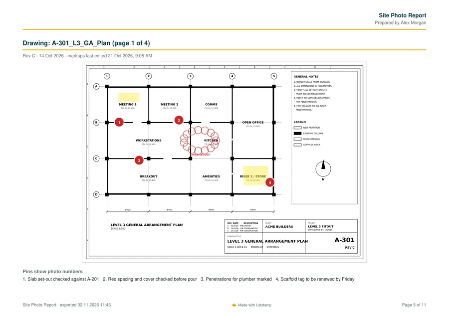
Report page with a marked-up floor plan drawing
Drawing A-301 · markups and photo pins
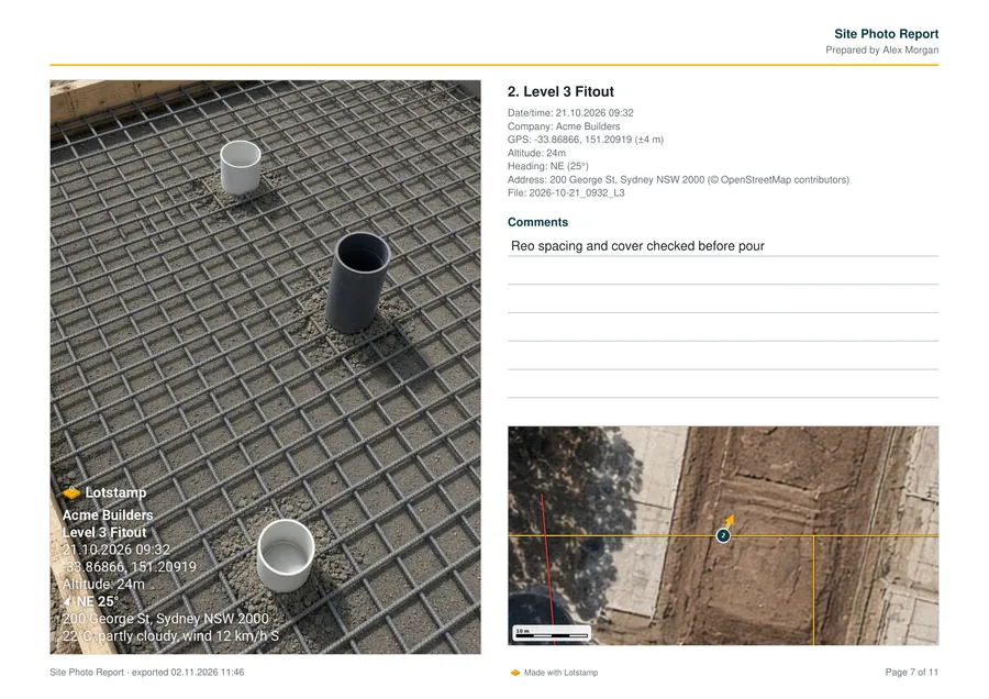
Report photo page with stamp details, comments and mini map
Photo page · stamp, comments, mini map
PDF reportExcel: Photos · Defects · SummarySite diary PDFMade with Lotstamp footer
Everything in Lotstamp

One app for the whole site record.

The camera is where it starts. Here is everything else that comes with it.

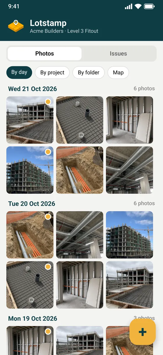
Photos by day, project or folder

Your gallery sorts itself. Switch between day, project, folder and map views, or search.

Issues and defects

Flag a photo as an issue with priority, category, assignee and due date. Track open and closed.

Models and markup

Import DXF, KML or GeoJSON and toggle each layer. Draw lines, areas, points and notes.

Floor plans and drawings PRO

Open a PDF plan, pin photos to it, search text and bookmark pages. Link folders from Drive or Files.

Measure with snapping PRO

Set a scale once, then measure lengths and areas on plans and the map.

Site diary PRO

Daily notes with photos and marked-up plans, saved as a tidy A4 PDF.

Checklists PRO

Run a checklist from the camera so every required shot gets taken.

Camera ghost and time-lapse PRO

Overlay a past photo to reshoot the same angle, then stitch the series into an MP4.

Stamp designer and presets PRO

Choose what goes on the stamp, where it sits and how it looks. Save setups for each job.

Calendar and reminders PRO

Defects and photo reminders in one calendar, synced to your phone or Outlook calendar.

Stamped video

Record video with the same stamp on every frame.

Fix the pin

Nudge a photo's location and re-geocode the address. Reports note any adjusted location.

Pricing

Free to start. Pro when the job grows.

Prices in Australian dollars. Cancel any time through your app store account.

Free

A$0

Everything you need to stamp and report.

  • GPS and address stamp camera
  • Full-size photos, or pick your size
  • Gallery by day, project and folder
  • Map with direction pins and CAD layers
  • PDF and Excel reports

Lotstamp Pro

A$9.99 / month

or A$59.99 / year, half the monthly price.

  • Everything in Free
  • Google Drive cloud sync
  • Calendar, reminders and calendar sync
  • Floor plans, measuring and site diary
  • Checklists, camera ghost and time-lapse
  • Stamp designer and your own presets

Get Lotstamp on your next site visit.

Free on Android today. The iPhone version is on its way to the App Store.

Get it onGoogle Play Coming soonApp Store
Lotstamp gallery sorted by day